
4-Day Great Smoky Mountains Itinerary: Skip the Crowds
This post contains affiliate links. As an Amazon Associate, we earn from qualifying purchases.
A 4-day Great Smoky Mountains itinerary splits cleanly into two days on the Tennessee side and two on the North Carolina side, anchored by Cades Cove and Newfound Gap Road. Enter before 8 a.m. Or after 3 p.m., buy a parking tag for any stop over 15 minutes, and skip timed-entry booking because the Smokies don’t use it.
Those two halves of the park behave like separate trips, and the road between them eats more of the day than the map suggests. Newfound Gap Road runs about 35 miles between Gatlinburg and Cherokee and climbs roughly 3,000 feet getting there. A Tennessee morning plus a North Carolina afternoon fills a full day.
What follows is the route I’d drive, the timing rules that decide whether it works, and the four places where the official park plan and the popular blog itineraries disagree.
Key Takeaways
- Buy the parking tag before you leave the house. Any vehicle parked more than 15 minutes needs one, and entrance to the park itself stays free.
- Enter before 8 a.m. Or after 3 p.m. Most visitors arrive between 10:00 and 11:00 a.m., which is exactly when the trailhead lots fill.
- Treat Cades Cove as a half-day. The 11-mile one-way loop takes 2 to 4 hours, and it sits an hour’s drive from Sugarlands.
- There’s nothing to reserve. The Smokies run on first-come parking, so your arrival time is the only lever you control.
- Download your maps in town. Cell coverage inside the park is very limited, and navigation apps send drivers the wrong way on one-way roads.
The Parking Tag Rule That Reshapes a 4-Day Great Smoky Mountains Itinerary
Buy the parking tag before you argue about anything else. It’s the only hard rule in this park that costs you the trip if you miss it.
A parking tag is required for any vehicle parked inside Great Smoky Mountains National Park for more than fifteen minutes. Tags are sold by the day, week, or year, and they do not reserve a specific space, location, or time frame. Entrance to the park itself remains free, and no timed-entry reservation system operates here.
The tag covers parking only. It applies at Cades Cove and other parking areas in the park (the same tag, one purchase).
NPS pushes visitors toward off-peak hours, days, and seasons. This park has no timed-entry reservations, which changes how you plan.
The park also runs no shuttle service of its own. Outside businesses fill that gap during peak season, running March through October. That matters if you want to hike a ridge one-way and ride back.
Sort these four things before you book anything else:
- Parking tag. Required for any stop longer than 15 minutes, sold by the day, week, or year.
- Lodging. The park has campgrounds and one hike-in lodge. Nothing else.
- Shuttle. The park operates zero. Outside companies cover March through October, which matters for one-way ridge hikes.
- Maps. Download before you drive in.
Get those four right and the rest of the trip is mostly choosing where to point the car.
Why the 10 A.M. Arrival Window Wrecks Day One
Between 10:00 and 11:00 a.m., the park’s lots fill.
That hour is the whole problem. NPS tracks arrival volume and publishes the pattern, and its own advice is to enter no later than 8 a.m. During the busiest times, earlier still for popular trailheads.
The park publishes its own NPS traffic and travel tips, which includes a day-rating system. Green Circle days mean open roads and open lots. Yellow Triangle days mean moderate congestion and many full lots. Red Diamond days mean heavy congestion and completely full lots at most destinations.
By mid-morning on a Red Diamond Saturday, the Cades Cove entrance is a slow ribbon of brake lights with no exit.
A second window works. Entering around 3 p.m. Can also be a good time to visit, and late-afternoon hikes dodge the worst of the crowd. Check the sunset time first, pack a headlamp, and expect curvy mountain roads after dark.
If you can’t be parked by 8 a.m., don’t start the day at a popular trailhead. Start it at a picnic area and hike at 3 p.m. Instead.
Common mistake: Treating a 3 p.m. Arrival as a free pass. The lots do thin out, but daylight doesn’t stretch with them, and a late start on a 3-hour trail puts you on mountain roads in the dark.
How Long Does a Smoky Mountains Trip Actually Need?
Four days covers the headline sights plus one genuinely long hike.
Two days is the floor if you want Newfound Gap Road and Cades Cove. Three days buys you a couple of waterfall hikes. Four days gives you enough time for a full day on a longer trail or a trip to Gatlinburg and Cherokee. Five days covers every trail on the standard list, or leaves room to relax in a cabin outside the park.
The park covers 522,427 acres, split almost evenly between Tennessee and North Carolina. It holds over 800 miles of hiking trails, and National Park Bucket List puts annual visitation at over 14 million. Trip length matters more here than at a smaller park.
What each trip length buys you:
- 2 days. Newfound Gap Road and Cades Cove. That’s it, and that’s fine.
- 3 days. Add a couple of waterfall hikes, like Grotto Falls or Alum Cave Bluffs.
- 4 days. One full day on a longer trail, or a day in Gatlinburg or Cherokee.
- 5 days. Every trail on the list, plus time to sit still.
The 4-Day Route, Day by Day, With Drive Times Attached
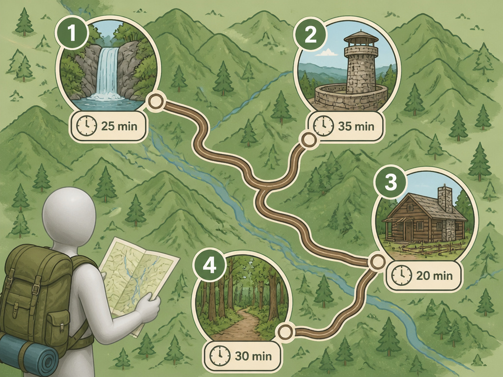
Four days, four different starting points, and one rule that applies to all of them: be parked before 8 a.m.
Before you start: The last 35 feet of the Chimney Tops summit is polished metamorphic slate, a smooth rock face that turns slick when wet, and NPS rates it extremely hazardous in inclement weather. Summits run 10 to 20 degrees Fahrenheit cooler than the valleys, so a warm morning in Townsend can be a cold ridge by noon. Cell coverage inside the park is very limited, so download your maps before you drive in.
Day 1: Sugarlands, Cataract Falls, and the Cades Cove Question
Cataract Falls starts at the Sugarlands Visitor Center, which makes it the easiest first stop in the park. The trail runs 0.7 miles to a 40-foot waterfall and takes 30 minutes to an hour.
Add the optional 1-mile Fighting Creek loop to the John Ownby cabin and you’ve burned about 30 extra minutes.
The park publishes its own Sugarlands Visitor Center itinerary, which anchors Day 1 at Cataract Falls and treats Cades Cove as a separate hour-long drive.
Cades Cove sits an hour’s drive from Sugarlands. The loop is 11 miles, one-way, meaning you drive it in a single direction with no turning back, and touring takes 2 to 4 hours. Over 16 original historic structures still stand along the route.
Day 2: Newfound Gap Road and Kuwohi
Newfound Gap Road covers about 35 miles between Gatlinburg and Cherokee. The climb crosses forest zones that look like a drive from Georgia to Maine.
Kuwohi is the highest point in Tennessee, 45 minutes from Sugarlands, with a 360-degree observation tower at the top. The paved trail up is short and steep.
Day 3: Roaring Fork and a Waterfall
Roaring Fork Motor Nature Trail takes 30 minutes to drive from Sugarlands and about an hour to tour. NPS adds a note to allow extra time for the home sites, plus another hour if you stop at the historic homes.
Grotto Falls sits on the Trillium Gap Trail off Roaring Fork. The falls drop 25 feet, the round trip takes about 2 hours, and the trailhead is 10 minutes from Sugarlands.
The blog consensus treats Roaring Fork as a full day paired with two waterfall hikes, roughly 8 miles total, or a longer route up Mount Le Conte. NPS’s own suggested pairing is Grotto Falls alone.
Day 4: Cades Cove, a Long Hike, or a Town Day
If you skipped Cades Cove on Day 1, Day 4 is the natural slot for it. Otherwise, pick one long trail or leave the park entirely.
Hen Wallow Falls drops 95 feet off the Gabes Mountain Trail. It’s 4.4 miles roundtrip, takes 3 to 4 hours, and sits 45 minutes from Sugarlands.
| Destination | Drive From Sugarlands | Time On Foot or Wheels |
|---|---|---|
| Cataract Falls | On site | 30 min to 1 hr |
| Grotto Falls | 10 min | 2 hrs |
| Chimney Tops | 25 min | 3 hrs |
| Kuwohi | 45 min | 1 hr hiking |
| Hen Wallow Falls | 45 min | 3 to 4 hrs |
| Cades Cove | 1 hr | 2 to 4 hrs touring |
The four bookings to make, in order:
- Parking tag. It’s the only item with a hard rule attached, so it goes first.
- Lodging. Decide inside the park or outside before you plan anything else.
- Shuttle. Only if you’re hiking a ridge one-way on a busy weekend.
- LeConte Lodge. It books through its own reservation line at (865) 429-5704 or the lodge website, not through the park.
Where the Official NPS Route and the Blog Consensus Split
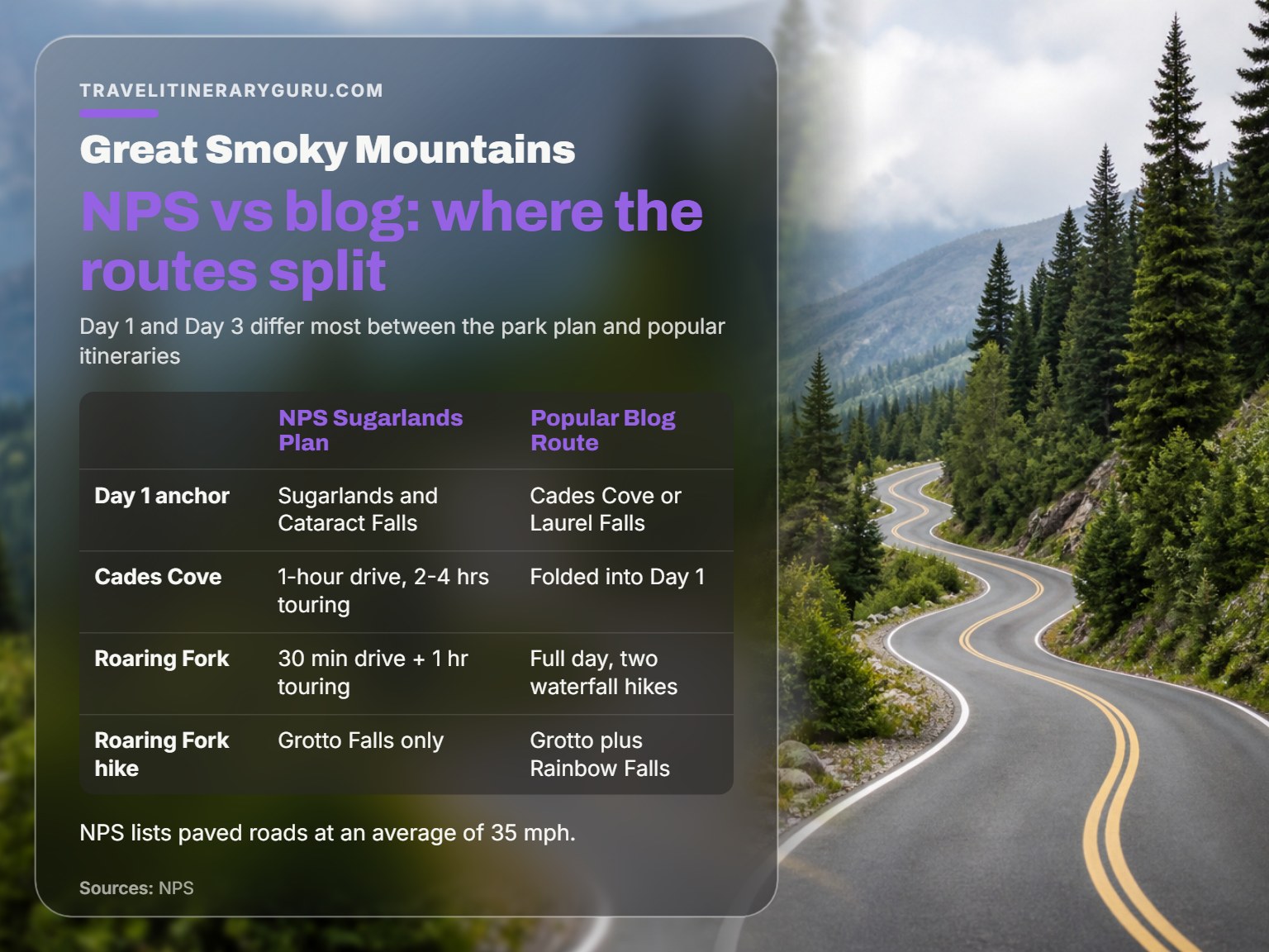
The official park plan and the popular blog itineraries don’t line up, and the gap matters most on Day 1 and Day 3.
| Question | NPS Sugarlands Plan | Popular Blog Route |
|---|---|---|
| Day 1 anchor | Sugarlands and Cataract Falls | Cades Cove or Laurel Falls |
| Cades Cove placement | Separate 1-hour drive, 2 to 4 hrs touring | Folded into Day 1 with Little River Gorge |
| Roaring Fork timing | 30 min drive, 1 hr touring, plus 1 hr for homes | Full day with two waterfall hikes |
| Roaring Fork pairing | Grotto Falls only | Grotto plus Rainbow Falls |
| Chimney Tops summit | Last 35 ft extremely hazardous when wet | Routine stop, no hazard note |
Day 1 is the biggest split. NPS anchors the day at Sugarlands and treats Cades Cove as an hour away with 2 to 4 hours of touring. The blog version opens with Cades Cove or Laurel Falls depending on which city you fly into, then adds Little River Gorge Road to the same day.
Roaring Fork splits twice. On timing, NPS lists 30 minutes of driving plus an hour of touring, with extra time allowed for the home sites. On pairing, NPS suggests Grotto Falls alone, while the blog version combines Grotto and Rainbow Falls into roughly 8 miles.
Chimney Tops is the one that matters for safety. NPS warns the final 35 feet is extremely hazardous in inclement weather and urges extreme caution. The blog version lists it as a routine Day 2 stop with no caveat.
Which plan wins? The one with drive times attached.
Use the park’s timings as your clock and the blog route as your wish list. When the two conflict, the measured numbers win, because someone actually drove them.
The NPS auto touring guide lists paved roads at an average of 35 mph.
Which Hikes Earn a Slot in Four Days?
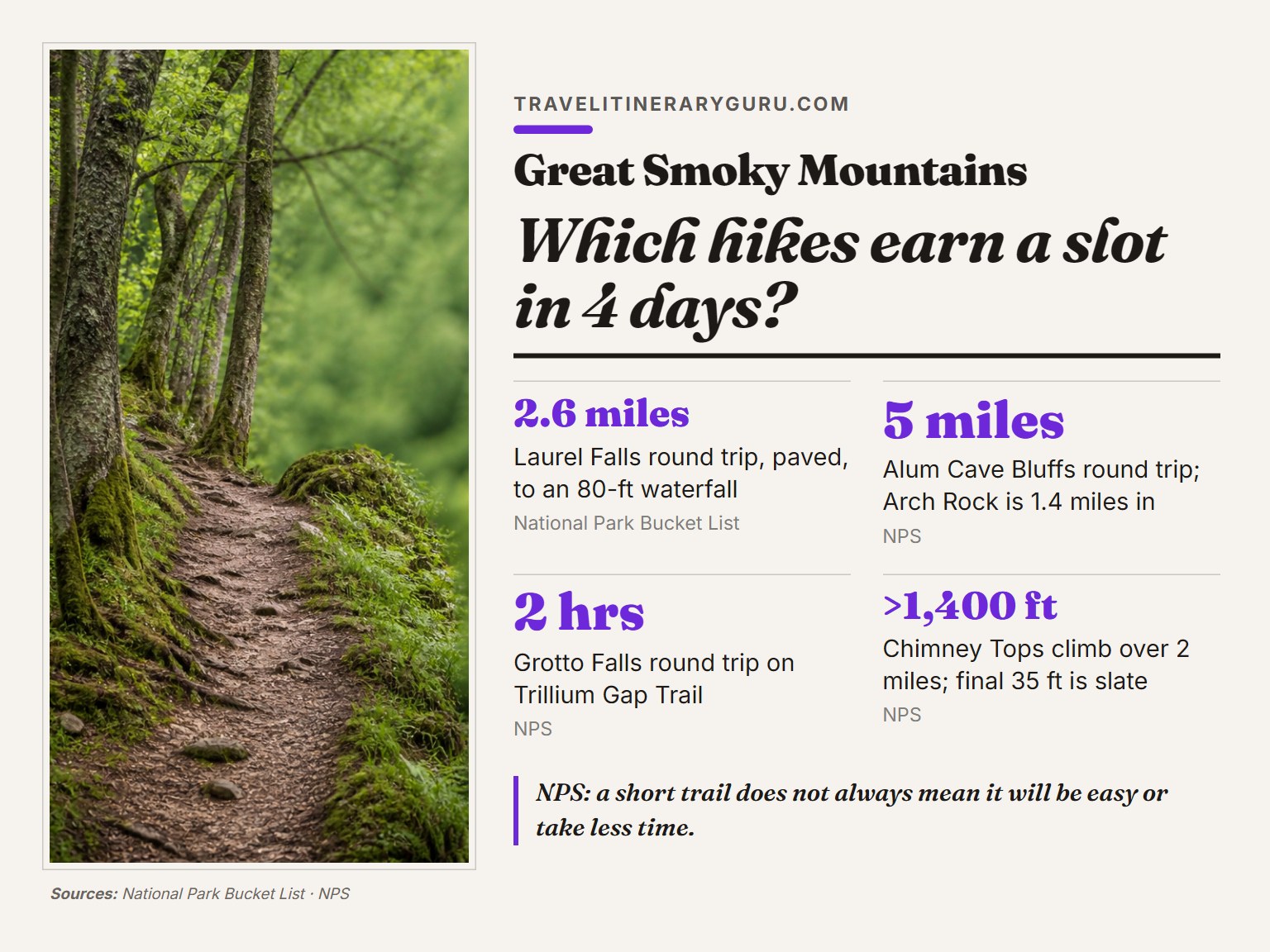
Chimney Tops earns its slot, right up until the last 35 feet.
The Three Hikes Worth Your Legs
- Grotto Falls. A 25-foot waterfall on the Trillium Gap Trail off Roaring Fork, 2 hours round trip, 10 minutes from Sugarlands.
- Alum Cave Bluffs. Arch Rock sits 1.4 miles from the trailhead, and the round trip to the bluffs is 5 miles. Push on to Mount LeConte and you’re looking at 10 miles.
- Laurel Falls. A paved 2.6-mile round trip to an 80-foot waterfall. Moderately difficult, and parking is limited, so go early or late.
The One to Skip When It’s Wet
Chimney Tops climbs more than 1,400 feet over 2 miles and takes about 3 hours. NPS rates the trail Moderate to Strenuous, and the final 35 feet is the polished slate.
Skip it in the rain.
Where this goes sideways: Starting Chimney Tops at 2 p.m. On a wet day. The slate at the top turns slick, the descent runs in fading light, and NPS’s own language is “extremely hazardous in inclement weather.”
NPS makes a point that catches people out. A short trail doesn’t always mean an easy one or a faster one.
The NPS day hikes list is a useful resource for matching a trail to the people in your car.
About 70 miles of the Appalachian Trail crosses through the park, and Charlies Bunion is an 8-mile roundtrip along it from the Newfound Gap parking area.
Why Does Your GPS Fail Inside the Smokies?
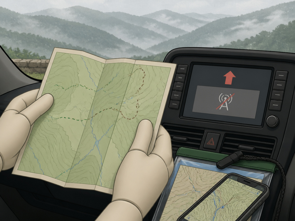
You pull into Newfound Gap, open your phone, and the map is a grey rectangle.
NPS says cellular coverage inside the park is very limited. It also warns that vehicle navigation systems and GPS units can send drivers the wrong way down one-way roads or to dead ends in remote areas.
The fix is old-fashioned. Free park road maps sit at every visitor center, and the park’s own maps are GPS-enabled, so they work inside commercial mapping apps even without a signal.
A free app with detailed 2017 topographic maps handles offline navigation, and the NPS Great Smoky maps page has more information.
For hiking, detailed waterproof maps are available online and at visitor centers from Smokies Life. They don’t run out of battery.
Navigation apps work fine in the gateway towns and fail the moment you drop into a valley. Download the route before you lose signal, or carry paper.
Easy to miss: The map on your dashboard screen. If it’s a factory navigation system, NPS specifically warns it can route you the wrong way on one-way roads. Paper first, screen second.
Inside the park, your phone goes quiet.
Where to Sleep, and What to Do With a Spare Half-Day
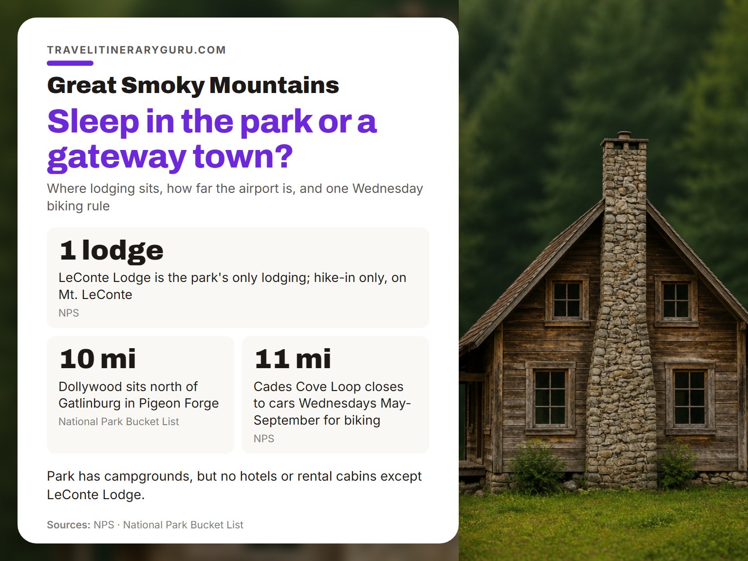
Lodging in the Smokies splits into two camps, and the park only owns one of them.
Inside the park you get campgrounds and LeConte Lodge. That’s the whole list. LeConte Lodge sits on the summit of Mount LeConte and is reachable only by hiking, with reservations handled by phone at (865) 429-5704 or through the lodge’s own website.
Everything else sits in the gateway towns. Gatlinburg, Townsend, Cherokee, and Pigeon Forge all put you within a short drive of an entrance.
McGhee Tyson Airport in Alcoa sits about 25 miles from the Townsend entrance and 40 miles from Gatlinburg and the Sugarlands Visitor Center.
Spare half-day options that don’t require a trailhead:
- Dollywood. 10 miles north of Gatlinburg in Pigeon Forge, if you want a break from trails.
- Little Greenbrier School and Walker Sisters cabin. A 1.2-mile walk to two historic buildings.
- Cosby Nature Trail. A short loop around Cosby Creek in the park’s quiet corner.
One scheduling note worth knowing: Wednesdays from May through September, the Cades Cove loop closes to motor vehicles, which turns it into a biking route.
Frequently Asked Questions
Do you need a reservation to enter Great Smoky Mountains National Park?
No. Entrance is free and there are no timed-entry reservation systems at the park. You do need a parking tag for any vehicle parked more than 15 minutes, and tags come in daily, weekly, and annual versions.
How early should you arrive to avoid crowds?
NPS recommends entering no later than 8 a.m. During the busiest times, and earlier for popular trailheads. Most visitors arrive between 10:00 and 11:00 a.m., so a 3 p.m. Start works as a second option if you’ve checked the sunset time.
Can you see the Smokies without hiking?
Yes. Newfound Gap Road runs about 35 miles between Gatlinburg and Cherokee, and Cades Cove is an 11-mile one-way loop you drive. Kuwohi has a paved trail to a 360-degree tower, and the climb is short and steep.
Is Cades Cove worth a full half-day?
Plan on 2 to 4 hours for the loop plus an hour of driving each way from Sugarlands. Over 16 original historic structures still stand along the route, so the stops add up fast.
Where do you stay inside the park?
Campgrounds, plus LeConte Lodge on the summit of Mount LeConte. The lodge is hike-in only, and reservations go through its own line at (865) 429-5704 or its website. There are no hotels or rental cabins inside the park.
What’s the hardest part of planning this trip?
Timing. The park runs on first-come parking, so your arrival time decides your day more than any trail choice does. Get that wrong and the rest of the plan can’t recover.
The Bottom Line
One rule carries more weight than the rest. If you control one thing on a 4-day Great Smoky Mountains itinerary, control your arrival time. Park by 8 a.m. Or roll in after 3 p.m., and the trip mostly takes care of itself.
One caveat: this plan assumes you’re driving. Fly into McGhee Tyson and Day 1 has to shrink, because the airport sits about 25 miles from the Townsend entrance and 40 from Gatlinburg.
And one stance I’ll defend. I’d rather see you skip Cades Cove entirely than drive that loop at 11 a.m. On a Saturday in October. You’d spend four hours in a brake-light parade and remember none of it.
Pick your two anchors, build the rest around arrival times, and leave one afternoon empty. The empty afternoon is where the trip actually happens.
